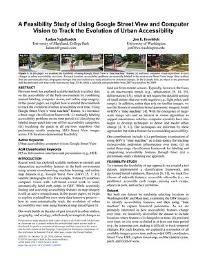
Recent work has explored scalable methods to identify and characterize accessibility features in the built environment using remote crowdsourcing, machine learning, and online map datasets. For example, Tohme combines computer vision with web-based crowd work to semiautomatically label curb ramps in GSV. While accurately finding and assessing accessibility features in map imagery is still an active research area, in this research, we begin to explore a related but even more data-intensive process— how to semi-automatically track the evolution of urban accessibility over time using historical map data.
The long-term goal of this work is to develop accurate and scalable methods for tracking how urban accessibility changes over time. With the resulting temporal datasets, our hope is to enable new data-driven research inquiries such as: what geo-spatial and socio-economic factors seem to correlate with changes in urban accessibility? How do temporal patterns of urban accessibility compare across cities in the US and beyond? What are the appropriate models and metrics to capture this change? Can we build predictive models of accessibility evolution?
![Illustration of a multi-story indoor house layout used in the CapNav benchmark. The diagram asks: “Can [AGENT] go from the basement foyer to the top floor rest area?” The basement foyer (START) is at the bottom left, and the top floor rest area (END) is at the top right. Colored paths show different possible routes through labeled areas including Garage, First Floor Hallway, and Elevator. Icons on the left represent four agent types: a wheelchair user (allowed, green check), a quadruped robot (allowed, green check), a human (allowed, green check), and a sweeping robot (not allowed, red X). Red X markers and warning labels indicate constraints such as “Cannot go up stairs” and “Cannot operate elevator,” showing how different mobility capabilities affect route feasibility.](/media/projects/images/CapNav-Thumbnail.png.500x300_q85_box-135%2C10%2C2826%2C1627_crop_upscale.png)